
Make a donation
Gear up for your next adventure:
As an Amazon Associate, this site earns from qualifying purchases at no extra cost to you.
El Tarra topographic map
Click on the map to display elevation.
Make a donation
Gear up for your next adventure:
As an Amazon Associate, this site earns from qualifying purchases at no extra cost to you.
El Tarra
El municipio de El Tarra está localizado a una altitud de 270 metros sobre el nivel del mar y su extensión es de 675 km². La temperatura media es de 28 °C. Distancia: 159 km de Cúcuta. Sus coordenas geográficas es: Longitud al oeste de Greenwich 73.º 59' y Latitud Norte 8.º 35'.
Make a donation
Gear up for your next adventure:
As an Amazon Associate, this site earns from qualifying purchases at no extra cost to you.
About this map
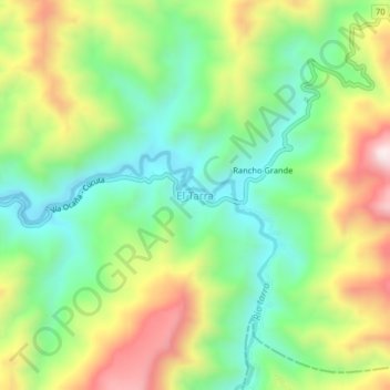
Name: El Tarra topographic map, elevation, terrain.
Average elevation: 5,358 ft
Minimum elevation: 4,547 ft
Maximum elevation: 6,624 ft
Make a donation
Gear up for your next adventure:
As an Amazon Associate, this site earns from qualifying purchases at no extra cost to you.