
Make a donation
Gear up for your next adventure:
As an Amazon Associate, this site earns from qualifying purchases at no extra cost to you.
Vitré topographic map
Click on the map to display elevation.
Make a donation
Gear up for your next adventure:
As an Amazon Associate, this site earns from qualifying purchases at no extra cost to you.
Vitré
The land area of Vitré: 37.19 km2 (14.36 sq mi). The average altitude of Vitré is approximately 89 m. The highest point, 127 m, is found in the "Ménardières" zone, at Pierre and Marie Curie Street. The lowest point, 67 m, is close to the firm S.V.A.'s location under the viaduct of the ring-road.
Make a donation
Gear up for your next adventure:
As an Amazon Associate, this site earns from qualifying purchases at no extra cost to you.
About this map
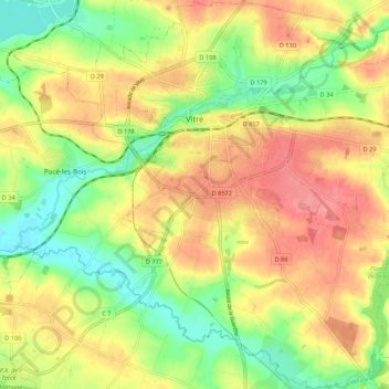
Name: Vitré topographic map, elevation, terrain.
Average elevation: 308 ft
Minimum elevation: 171 ft
Maximum elevation: 433 ft
Make a donation
Gear up for your next adventure:
As an Amazon Associate, this site earns from qualifying purchases at no extra cost to you.