Geolocate

Aguinaldo topographic map

Click on the map to display elevation.

About this map

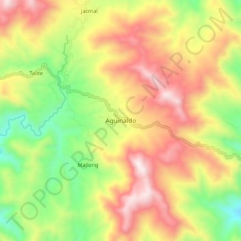
Name: Aguinaldo topographic map, elevation, terrain.

Location: Aguinaldo, Ifugao, Philippines (16.93819 121.28811 17.01819 121.36811)

Average elevation: 2,946 ft

Minimum elevation: 1,316 ft

Maximum elevation: 4,662 ft

Other topographic maps

Click on a map to view its topography, its elevation and its terrain.

Batad Residential

Philippines > Ifugao > Banaue > Batad

Average elevation: 3,343 ft

Gear up for your next adventure:

🔦Compact Flashlight - Reliable flashlight for emergencies
🛏️Cold Weather Sleeping Bag - Warm sleeping bag for cold conditions
🥇GPS Hiking Watch - Multi‑sport GPS watch with navigation and trail tracking
🧢Outdoor Hiking Hat - Sun protection hat for outdoor explorers
🧯Portable Fire Pit - Compact fire pit for camping spots

As an Amazon Associate, this site earns from qualifying purchases at no extra cost to you.