
Make a donation
Gear up for your next adventure:
As an Amazon Associate, this site earns from qualifying purchases at no extra cost to you.
Oorbeek topographic map
Click on the map to display elevation.
Make a donation
Gear up for your next adventure:
As an Amazon Associate, this site earns from qualifying purchases at no extra cost to you.
Oorbeek
Oorbeek ligt in Haspengouw op een hoogte van 45-100 meter.
Make a donation
Gear up for your next adventure:
As an Amazon Associate, this site earns from qualifying purchases at no extra cost to you.
About this map
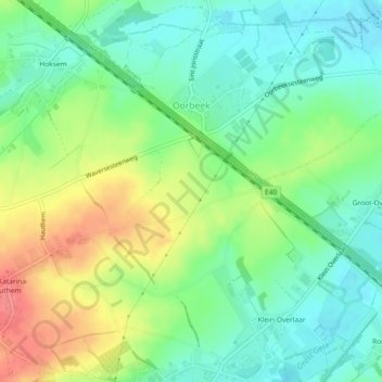
Name: Oorbeek topographic map, elevation, terrain.
Location: Oorbeek, Tienen, Leuven, Vlaams-Brabant, Vlaanderen, België (50.77915 4.88333 50.80529 4.92939)
Average elevation: 223 ft
Minimum elevation: 138 ft
Maximum elevation: 354 ft
Make a donation
Gear up for your next adventure:
As an Amazon Associate, this site earns from qualifying purchases at no extra cost to you.
Other topographic maps
Click on a map to view its topography, its elevation and its terrain.
Make a donation
Gear up for your next adventure:
As an Amazon Associate, this site earns from qualifying purchases at no extra cost to you.