
Neuss topographic map
Click on the map to display elevation.
About this map
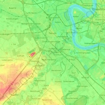
Name: Neuss topographic map, elevation, terrain.
Location: Neuss, Rhein-Kreis Neuss, North Rhine-Westphalia, Germany (51.11676 6.61482 51.23561 6.79836)
Average elevation: 144 ft
Minimum elevation: 66 ft
Maximum elevation: 272 ft
Other topographic maps
Click on a map to view its topography, its elevation and its terrain.
Moll
Germany > North Rhine-Westphalia > Kreis Viersen > Kempen > Unterweiden
Average elevation: 125 ft
Plettenburg
Germany > North Rhine-Westphalia > Rheinisch-Bergischer Kreis > Wermelskirchen > Grunewald
Average elevation: 758 ft