
Make a donation
Gear up for your next adventure:
As an Amazon Associate, this site earns from qualifying purchases at no extra cost to you.
Schönbrunn topographic map
Click on the map to display elevation.
Make a donation
Gear up for your next adventure:
As an Amazon Associate, this site earns from qualifying purchases at no extra cost to you.
Schönbrunn
Schönbrunn liegt nordwestlich der Stadt Lengenfeld im Osten des Naturraumes Vogtland sowie im sächsischen Teil des historischen Vogtlands. Der Ort befindet sich in einer Höhe von ca. 370 m NHN im Göltzschtal. Die Dorfflur umfasst etwa 980 Hektar.
Make a donation
Gear up for your next adventure:
As an Amazon Associate, this site earns from qualifying purchases at no extra cost to you.
About this map
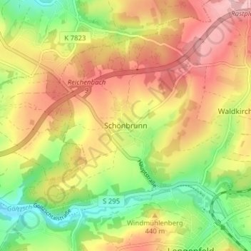
Name: Schönbrunn topographic map, elevation, terrain.
Average elevation: 1,388 ft
Minimum elevation: 1,129 ft
Maximum elevation: 1,627 ft
Make a donation
Gear up for your next adventure:
As an Amazon Associate, this site earns from qualifying purchases at no extra cost to you.