
Make a donation
Gear up for your next adventure:
As an Amazon Associate, this site earns from qualifying purchases at no extra cost to you.
Pantepec topographic map
Click on the map to display elevation.
Make a donation
Gear up for your next adventure:
As an Amazon Associate, this site earns from qualifying purchases at no extra cost to you.
Pantepec
Pantepec chiapas se encuentra localizado al norte del territorio del estado de Chiapas, en la región denominada como Región V Norte. Su extensión territorial es de 106.025 kilómetros cuadrados que representan el 0.14% de la extensión del territorio estatal. Sus coordenadas geográficas extremas son 17° 06' - 17° 17' de latitud norte y 92° 57' - 93° 08' de longitud oeste y su altitud va desde un mínimo de 800 hasta un máximo de 2 200 metros sobre del nivel del mar.
Make a donation
Gear up for your next adventure:
As an Amazon Associate, this site earns from qualifying purchases at no extra cost to you.
About this map
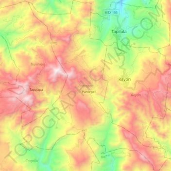
Name: Pantepec topographic map, elevation, terrain.
Location: Pantepec, Chiapas, México (17.10768 -93.12232 17.28132 -92.96517)
Average elevation: 4,728 ft
Minimum elevation: 1,647 ft
Maximum elevation: 7,884 ft
Make a donation
Gear up for your next adventure:
As an Amazon Associate, this site earns from qualifying purchases at no extra cost to you.
Other topographic maps
Click on a map to view its topography, its elevation and its terrain.
Make a donation
Gear up for your next adventure:
As an Amazon Associate, this site earns from qualifying purchases at no extra cost to you.