Geolocate

Williford topographic map

Click on the map to display elevation.

About this map

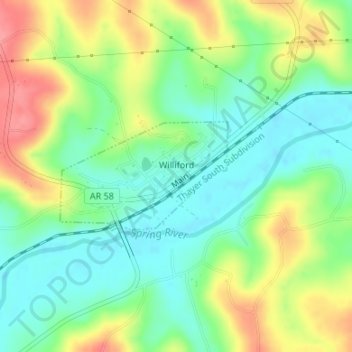
Name: Williford topographic map, elevation, terrain.

Location: Williford, Sharp County, Arkansas, 72482, United States (36.24759 -91.36845 36.25599 -91.35248)

Average elevation: 400 ft

Minimum elevation: 292 ft

Maximum elevation: 564 ft

Sharp County trails, hiking, mountain biking, running and outdoor activities

Other topographic maps

Click on a map to view its topography, its elevation and its terrain.

Poughkeepsie

United States > Arkansas > Sharp County

Average elevation: 469 ft

Gear up for your next adventure:

👟Trail Running Shoes - Lightweight shoes for trail runners
🔊Portable Camp Speaker - Music and alerts at camp
🧢Sun Protection Hats - Wide-brimmed and UPF-rated hats for high-altitude sun safety
🏕️Family Camping Gear - Essentials for group camping trips
🎒Outdoor Daypacks - Lightweight backpacks designed for carrying maps and essential gear

As an Amazon Associate, this site earns from qualifying purchases at no extra cost to you.