Geolocate

94424 topographic map

Click on the map to display elevation.

About this map

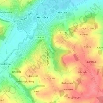
Name: 94424 topographic map, elevation, terrain.

Location: 94424, Hainberg, Arnstorf, Landkreis Rottal-Inn, Bayern, Deutschland (48.50112 12.75211 48.60799 12.89582)

Average elevation: 1,385 ft

Minimum elevation: 1,145 ft

Maximum elevation: 1,578 ft

Other topographic maps

Click on a map to view its topography, its elevation and its terrain.

Hinteröd

Deutschland > Bayern > Landkreis Rottal-Inn > Arnstorf > Hainberg

Average elevation: 1,362 ft

Gear up for your next adventure:

🔌USB Car Charger - Car charger for on‑the‑go power needs
🎒Trekking Poles - Sturdy poles for balance and stability on rough terrain
📚USA Hiking Guide Books - Top trail guides and map books
🧣Merino Neck Gaiters - Multi-functional headwear for wind and sun protection
😴Insulated Sleeping Pads - Compact and warm pads for high-elevation camping

As an Amazon Associate, this site earns from qualifying purchases at no extra cost to you.