
Bighton topographic map
Click on the map to display elevation.
About this map
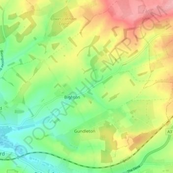
Name: Bighton topographic map, elevation, terrain.
Location: Bighton, Winchester, Hampshire, England, United Kingdom (51.09092 -1.14892 51.12544 -1.07209)
Average elevation: 397 ft
Minimum elevation: 213 ft
Maximum elevation: 646 ft
Other topographic maps
Click on a map to view its topography, its elevation and its terrain.
Farley Chamberlayne
United Kingdom > England > Hampshire > Winchester > Hursley
Average elevation: 348 ft
Dodsley Wood
United Kingdom > England > Hampshire > Winchester > East Stratton
Average elevation: 325 ft
Store House Gully
United Kingdom > England > Hampshire > Winchester > Fisher's Pond
Average elevation: 148 ft
Beacon Hill Nature Reserve
United Kingdom > England > Hampshire > Winchester > Exton
Average elevation: 420 ft
Headbourne Worthy
United Kingdom > England > Hampshire > Winchester > Kings Worthy
Average elevation: 217 ft
Old Winchester Hill Iron Age Fort
United Kingdom > England > Hampshire > Winchester
Average elevation: 404 ft
Lord's Wood
United Kingdom > England > Hampshire > Winchester > Colden Common
Average elevation: 118 ft
Brambridge
United Kingdom > England > Hampshire > Winchester > Colden Common > Brambridge
Average elevation: 121 ft
Norton Lake
United Kingdom > England > Hampshire > Winchester > Sutton Scotney > Norton
Average elevation: 236 ft