Geolocate

Mellor topographic map

Click on the map to display elevation.

About this map

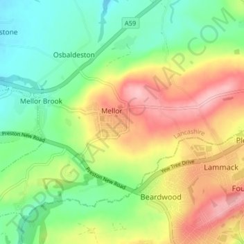
Name: Mellor topographic map, elevation, terrain.

Location: Mellor, Ribble Valley, Lancashire, England, United Kingdom (53.75620 -2.56455 53.78813 -2.49896)

Average elevation: 456 ft

Minimum elevation: 249 ft

Maximum elevation: 741 ft

Gear up for your next adventure:

🔦Powerful Headlamps - Ultra-bright hands-free lighting for night navigation
🧷Carabiner Set - Durable clips for gear attachment
🪶Survival Guide Book - Expert advice for emergency preparedness
📱Heavy-Duty Phone Cases - Drop-proof and waterproof protection for outdoor navigation
🪶Fire Starter Kit - Reliable fire starter for survival and camping

As an Amazon Associate, this site earns from qualifying purchases at no extra cost to you.