Make a donation
Gear up for your next adventure:
As an Amazon Associate, this site earns from qualifying purchases at no extra cost to you.
Pearl topographic map
Click on the map to display elevation.
Make a donation
Gear up for your next adventure:
As an Amazon Associate, this site earns from qualifying purchases at no extra cost to you.
About this map
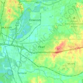
Name: Pearl topographic map, elevation, terrain.
Location: Pearl, Rankin County, Mississippi, United States (32.23559 -90.16726 32.32583 -90.03779)
Average elevation: 299 ft
Minimum elevation: 236 ft
Maximum elevation: 453 ft
Rankin County trails, hiking, mountain biking, running and outdoor activities
Make a donation
Gear up for your next adventure:
As an Amazon Associate, this site earns from qualifying purchases at no extra cost to you.
Other topographic maps
Click on a map to view its topography, its elevation and its terrain.
Make a donation
Gear up for your next adventure:
As an Amazon Associate, this site earns from qualifying purchases at no extra cost to you.
Make a donation
Gear up for your next adventure:
As an Amazon Associate, this site earns from qualifying purchases at no extra cost to you.
Hickory Glen
United States > Mississippi > Rankin County > Pearl > Hickory Glen
Average elevation: 302 ft
