Geolocate

Cobb topographic map

Click on the map to display elevation.

About this map

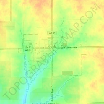
Name: Cobb topographic map, elevation, terrain.

Location: Cobb, Iowa County, Wisconsin, 53526, United States (42.95979 -90.34176 42.97277 -90.31737)

Average elevation: 1,178 ft

Minimum elevation: 1,106 ft

Maximum elevation: 1,227 ft

Iowa County trails, hiking, mountain biking, running and outdoor activities

Other topographic maps

Click on a map to view its topography, its elevation and its terrain.

Montfort Junction

United States > Wisconsin > Iowa County

Average elevation: 1,168 ft

Edmund

United States > Wisconsin > Iowa County

Average elevation: 1,152 ft

Jonesdale

United States > Wisconsin > Iowa County

Average elevation: 1,004 ft

Blue Mounds

United States > Wisconsin > Iowa County

Average elevation: 1,368 ft

Gear up for your next adventure:

👟Men's Trail Runners - Lightweight footwear for fast-paced exploration and light hiking
🧦Merino Wool Socks - Moisture-wicking, blister-preventing socks for long treks
🪶Thermal Camp Blanket - Extra warmth for cold nights
🪵Folding Camp Saw - Compact saw for wood and campsite work
🔌USB Car Charger - Car charger for on‑the‑go power needs

As an Amazon Associate, this site earns from qualifying purchases at no extra cost to you.