Geolocate

Tee Harbor topographic map

Click on the map to display elevation.

About this map

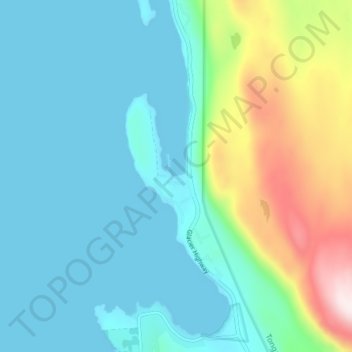
Name: Tee Harbor topographic map, elevation, terrain.

Location: Tee Harbor, Juneau, Alaska, United States (58.39041 -134.78004 58.43041 -134.74004)

Average elevation: 397 ft

Minimum elevation: -3 ft

Maximum elevation: 1,821 ft

Alaska trails, hiking, mountain biking, running and outdoor activities

Other topographic maps

Click on a map to view its topography, its elevation and its terrain.

Mendenhall Glacier

United States > Alaska > Juneau

Average elevation: 1,178 ft

Lemon Creek

United States > Alaska > Juneau

Average elevation: 1,414 ft

Lena Beach

United States > Alaska > Juneau > Lena Beach

Average elevation: 338 ft

West Juneau

United States > Alaska > Juneau

Average elevation: 361 ft

Gear up for your next adventure:

🌲Outdoor Survival Books - Best books on survival skills
🔪Outdoor Multitools - Essential survival tools for gear repair and field use
❄️Traction Cleats - Prevent slips on icy trails during winter hikes
🎒Trekking Poles - Sturdy poles for balance and stability on rough terrain
🧣Merino Neck Gaiters - Multi-functional headwear for wind and sun protection

As an Amazon Associate, this site earns from qualifying purchases at no extra cost to you.