Geolocate

Orbiston topographic map

Click on the map to display elevation.

About this map

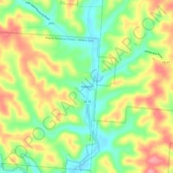
Name: Orbiston topographic map, elevation, terrain.

Location: Orbiston, Hocking County, Ohio, 43144, United States (39.46563 -82.18848 39.50563 -82.14848)

Average elevation: 840 ft

Minimum elevation: 679 ft

Maximum elevation: 1,027 ft

Hocking County trails, hiking, mountain biking, running and outdoor activities

Other topographic maps

Click on a map to view its topography, its elevation and its terrain.

Murray City

United States > Ohio > Hocking County

Average elevation: 843 ft

Rose Lake

United States > Ohio > Hocking County

Average elevation: 968 ft

Logan

United States > Ohio > Hocking County

Average elevation: 833 ft

Rose Lake Dam

United States > Ohio > Hocking County

Average elevation: 974 ft

Gear up for your next adventure:

🔊Portable Camp Speaker - Music and alerts at camp
🎒Trail Energy Bars - High‑calorie bars for hiking energy
📻Weather Alert Radios - Stay informed of storm risks while off-the-grid
🌡️Handheld Weather Meters - Measure wind, temp, and pressure for safe mountain travel
🧯Portable Fire Pit - Compact fire pit for camping spots

As an Amazon Associate, this site earns from qualifying purchases at no extra cost to you.