Wolfeck topographic map
Interactive map
Click on the map to display elevation.
About this map
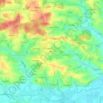
Name: Wolfeck topographic map, elevation, terrain.
Location: Wolfeck, Dorfen, Landkreis Erding, Bayern, 84419, Deutschland (48.27593 12.21358 48.31593 12.25358)
Average elevation: 1,499 ft
Minimum elevation: 1,391 ft
Maximum elevation: 1,663 ft
Other topographic maps
Click on a map to view its topography, its elevation and its terrain.
Eibach
Deutschland > Bayern > Landkreis Erding > Dorfen
Eibach, Dorfen, Landkreis Erding, Bayern, 84405, Deutschland
Average elevation: 1,578 ft
Lappach
Deutschland > Bayern > Landkreis Erding > Dorfen
Lappach, Dorfen, Landkreis Erding, Bayern, 84405, Deutschland
Average elevation: 1,568 ft
Schwindkirchen
Deutschland > Bayern > Landkreis Erding > Dorfen
Schwindkirchen, Dorfen, Landkreis Erding, Bayern, 84419, Deutschland
Average elevation: 1,535 ft