
Make a donation
Gear up for your next adventure:
As an Amazon Associate, this site earns from qualifying purchases at no extra cost to you.
Armagh topographic map
Click on the map to display elevation.
Make a donation
Gear up for your next adventure:
As an Amazon Associate, this site earns from qualifying purchases at no extra cost to you.
About this map
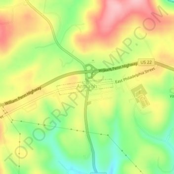
Name: Armagh topographic map, elevation, terrain.
Location: Armagh, Indiana County, Pennsylvania, United States (40.45232 -79.03820 40.45479 -79.02663)
Average elevation: 1,542 ft
Minimum elevation: 1,280 ft
Maximum elevation: 1,791 ft
Indiana County trails, hiking, mountain biking, running and outdoor activities
Make a donation
Gear up for your next adventure:
As an Amazon Associate, this site earns from qualifying purchases at no extra cost to you.
Other topographic maps
Click on a map to view its topography, its elevation and its terrain.
Robinson
United States > Pennsylvania > Indiana County > West Wheatfield Township
Average elevation: 1,302 ft
Penn Run
United States > Pennsylvania > Indiana County > Cherryhill Township
Average elevation: 1,562 ft
Elders Ridge
United States > Pennsylvania > Indiana County > Young Township
Average elevation: 1,201 ft
Make a donation
Gear up for your next adventure:
As an Amazon Associate, this site earns from qualifying purchases at no extra cost to you.
Make a donation
Gear up for your next adventure:
As an Amazon Associate, this site earns from qualifying purchases at no extra cost to you.