
Make a donation
Gear up for your next adventure:
As an Amazon Associate, this site earns from qualifying purchases at no extra cost to you.
Camiri topographic map
Click on the map to display elevation.
Make a donation
Gear up for your next adventure:
As an Amazon Associate, this site earns from qualifying purchases at no extra cost to you.
Camiri
El municipio de Camiri se encuentra en la región del Chaco boliviano, al sureste de Bolivia. Se encuentra rodeado por los macizos de Ñancahuazú al oeste, y Sararenda y Charagua al este, que son parte del subandino, es decir las últimas estribaciones orientales de la cordillera de los Andes. Presenta una topografía accidentada, con pendientes pronunciadas y discontinuas, así como algunos valles y planicies, especialmente en las riberas de los ríos.
Make a donation
Gear up for your next adventure:
As an Amazon Associate, this site earns from qualifying purchases at no extra cost to you.
About this map
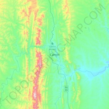
Name: Camiri topographic map, elevation, terrain.
Location: Camiri, Provincia Cordillera, Santa Cruz, Bolivia (-20.19907 -63.68035 -19.87907 -63.36035)
Average elevation: 3,182 ft
Minimum elevation: 2,303 ft
Maximum elevation: 6,178 ft
Make a donation
Gear up for your next adventure:
As an Amazon Associate, this site earns from qualifying purchases at no extra cost to you.