Geolocate

Manlag topographic map

Click on the map to display elevation.

About this map

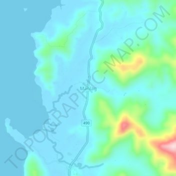
Name: Manlag topographic map, elevation, terrain.

Location: Manlag, El Nido, Palawan, Mimaropa, Philippines (11.09741 119.41360 11.13741 119.45360)

Average elevation: 135 ft

Minimum elevation: -3 ft

Maximum elevation: 951 ft

Other topographic maps

Click on a map to view its topography, its elevation and its terrain.

Shimizu Island

Philippines > Palawan > El Nido

Average elevation: 59 ft

Miniloc Island

Philippines > Palawan > El Nido

Average elevation: 89 ft

South Guntao Island

Philippines > Palawan > El Nido

Average elevation: 23 ft

Nacpan Beach

Philippines > Palawan > El Nido > Calitang

Average elevation: 118 ft

Lio Beach

Philippines > Palawan > El Nido > Villa Libertad

Average elevation: 43 ft

Gear up for your next adventure:

👖Convertible Hiking Pants - Versatile zip-off pants for changing altitudes and temperatures
🗃️Trail First Aid Kit - Essential kit for outdoor injuries and emergencies
🧺Microfiber Travel Towels - Compact and fast-drying towels for trail use
🥤Water Filter Bottle - All‑in‑one filter bottle for safe hydration
🌡️Handheld Weather Meters - Measure wind, temp, and pressure for safe mountain travel

As an Amazon Associate, this site earns from qualifying purchases at no extra cost to you.