Geolocate

Korogwe topographic map

Click on the map to display elevation.

About this map

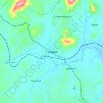
Name: Korogwe topographic map, elevation, terrain.

Location: Korogwe, Korogwe Town, Tanga Region, Northern Zone, Tanzania (-5.19921 38.41226 -5.11921 38.49226)

Average elevation: 1,122 ft

Minimum elevation: 935 ft

Maximum elevation: 2,293 ft

Other topographic maps

Click on a map to view its topography, its elevation and its terrain.

Handeni

Tanzania > Tanga Region

Average elevation: 1,253 ft

Korogwe

Tanzania > Tanga Region

Average elevation: 2,451 ft

Gear up for your next adventure:

🔥Plasma Lighters - Windproof lighters that work in any weather condition
🛠️Backpacking Tool Kit - Essential toolkit for outdoor repairs
🦶Hiking Gaiters - Keep debris and water out of your boots
🌄Hiking Binoculars - Compact binoculars for scenic views and trail spotting
😴Insulated Sleeping Pads - Compact and warm pads for high-elevation camping

As an Amazon Associate, this site earns from qualifying purchases at no extra cost to you.