Geolocate

Wabag topographic map

Click on the map to display elevation.

About this map

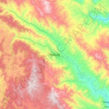
Name: Wabag topographic map, elevation, terrain.

Location: Wabag, Enga, Highlands Region, Papua New Guinea (-5.65194 143.56167 -5.33194 143.88167)

Average elevation: 8,173 ft

Minimum elevation: 5,459 ft

Maximum elevation: 11,076 ft

Other topographic maps

Click on a map to view its topography, its elevation and its terrain.

Yamb

Papua New Guinea > Enga > Kandep District

Average elevation: 7,648 ft

Yamb

Papua New Guinea > Enga > Kandep District

Average elevation: 7,648 ft

Gear up for your next adventure:

🎒Day Hiking Backpack - Lightweight backpack perfect for day trips and outdoor adventures
🔪Outdoor Multitools - Essential survival tools for gear repair and field use
🧣Hiking Neck Gaiter - Multi‑use neck protection for outdoor weather
🦟Ultrasonic Repellers - Create a bug-free zone at your camp or rest stop
🥇GPS Hiking Watch - Multi‑sport GPS watch with navigation and trail tracking

As an Amazon Associate, this site earns from qualifying purchases at no extra cost to you.