Geolocate

Lubong topographic map

Click on the map to display elevation.

About this map

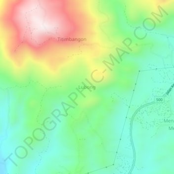
Name: Lubong topographic map, elevation, terrain.

Location: Lubong, Keningau, Interior Division, Sabah, Malaysia (5.30529 116.04638 5.34529 116.08638)

Average elevation: 1,916 ft

Minimum elevation: 1,125 ft

Maximum elevation: 3,317 ft

Other topographic maps

Click on a map to view its topography, its elevation and its terrain.

Sungai Pegalan

Malaysia > Sabah > Keningau

Average elevation: 1,486 ft

Sungai Pegalan

Malaysia > Sabah > Keningau

Average elevation: 1,486 ft

Gear up for your next adventure:

Backpacking Tent - Lightweight and durable tent for multi‑day hikes
🧣Merino Neck Gaiters - Multi-functional headwear for wind and sun protection
🏫Relief Map Kits - Hands-on tools for teaching landforms and elevation
👟Men's Trail Runners - Lightweight footwear for fast-paced exploration and light hiking
📷Action Camera - Capture your outdoor adventures in HD

As an Amazon Associate, this site earns from qualifying purchases at no extra cost to you.