Geolocate

Gaddesby topographic map

Click on the map to display elevation.

About this map

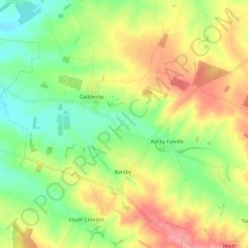
Name: Gaddesby topographic map, elevation, terrain.

Location: Gaddesby, Melton, Leicestershire, England, United Kingdom (52.68265 -1.01560 52.72877 -0.92570)

Average elevation: 344 ft

Minimum elevation: 207 ft

Maximum elevation: 509 ft

Other topographic maps

Click on a map to view its topography, its elevation and its terrain.

Old Dalby

United Kingdom > England > Leicestershire > Melton

Average elevation: 377 ft

Melton Mowbray

United Kingdom > England > Leicestershire > Melton

Average elevation: 338 ft

Burton Lazars

United Kingdom > England > Leicestershire > Melton

Average elevation: 315 ft

Bescaby

United Kingdom > England > Leicestershire > Melton > Sproxton

Average elevation: 502 ft

Rotherby

United Kingdom > England > Leicestershire > Melton

Average elevation: 253 ft

Twyford

United Kingdom > England > Leicestershire > Melton

Average elevation: 420 ft

Ashby Folville

United Kingdom > England > Leicestershire > Melton

Average elevation: 367 ft

Langham Brook

United Kingdom > England > Leicestershire > Melton > Saxby > Freeby

Average elevation: 308 ft

Sewstern

United Kingdom > England > Leicestershire > Melton

Average elevation: 446 ft

Harby

United Kingdom > England > Leicestershire > Melton

Average elevation: 174 ft

Knossington

United Kingdom > England > Leicestershire > Melton

Average elevation: 564 ft

Nether Broughton

United Kingdom > England > Leicestershire > Melton

Average elevation: 266 ft

Ragdale

United Kingdom > England > Leicestershire > Melton

Average elevation: 367 ft

Stonesby

United Kingdom > England > Leicestershire > Melton

Average elevation: 482 ft

Grimston

United Kingdom > England > Leicestershire > Melton

Average elevation: 400 ft

Saxelbye

United Kingdom > England > Leicestershire > Melton

Average elevation: 364 ft

Wycomb

United Kingdom > England > Leicestershire > Melton > Scalford

Average elevation: 433 ft

Brooksby

United Kingdom > England > Leicestershire > Melton > Rotherby

Average elevation: 249 ft

Pickwell

United Kingdom > England > Leicestershire > Melton

Average elevation: 551 ft

Burton Lazars

United Kingdom > England > Leicestershire > Melton

Average elevation: 315 ft

Melton Mowbray

United Kingdom > England > Leicestershire > Melton

Average elevation: 338 ft

Saltby

United Kingdom > England > Leicestershire > Melton

Average elevation: 472 ft

Great Dalby

United Kingdom > England > Leicestershire > Melton

Average elevation: 397 ft

Long Clawson

United Kingdom > England > Leicestershire > Melton

Average elevation: 256 ft

Hose

United Kingdom > England > Leicestershire > Melton

Average elevation: 190 ft

Asfordby Hill

United Kingdom > England > Leicestershire > Melton

Average elevation: 299 ft

Belvoir

United Kingdom > England > Leicestershire > Melton

Average elevation: 259 ft

Harby

United Kingdom > England > Leicestershire > Melton > Harby

Average elevation: 167 ft

Gear up for your next adventure:

🪄Magnetic Compass - Accurate compass for navigation
🪑Portable Camp Table - Compact table for campsite meals
🪶Compact Camp Shovel - Folding shovel for campsite tasks
🪶LED Camping Lantern - Bright lantern for camp lighting
📌Outdoor GPS Map App - Apps and devices for digital topographic navigation

As an Amazon Associate, this site earns from qualifying purchases at no extra cost to you.