
New Castle topographic map
Interactive map
Click on the map to display elevation.
About this map
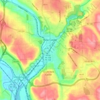
Name: New Castle topographic map, elevation, terrain.
Average elevation: 971 ft
Minimum elevation: 758 ft
Maximum elevation: 1,204 ft
Lawrence County trails, hiking, mountain biking, running and outdoor activities
Other topographic maps
Click on a map to view its topography, its elevation and its terrain.
North Edinburg
United States > Pennsylvania > Lawrence County > Mahoning Township
Average elevation: 915 ft
West Pittsburg
United States > Pennsylvania > Lawrence County > Taylor Township
Average elevation: 915 ft
West Pittsburg
United States > Pennsylvania > Lawrence County > Taylor Township
Average elevation: 915 ft
Lower East Side
United States > Pennsylvania > Lawrence County > New Castle > Lower East Side
Average elevation: 961 ft