
Make a donation
Gear up for your next adventure:
As an Amazon Associate, this site earns from qualifying purchases at no extra cost to you.
Muszyna topographic map
Click on the map to display elevation.
Make a donation
Gear up for your next adventure:
As an Amazon Associate, this site earns from qualifying purchases at no extra cost to you.
Muszyna
Muszyna lies in the valley of the Poprad, at an altitude of 450 metres (1,476 feet) above sea level. The town has the status of a spa, with the Poprad Landscape Park and the picturesque Poprad River Gorge located nearby.
Make a donation
Gear up for your next adventure:
As an Amazon Associate, this site earns from qualifying purchases at no extra cost to you.
About this map
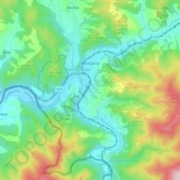
Name: Muszyna topographic map, elevation, terrain.
Average elevation: 1,909 ft
Minimum elevation: 1,427 ft
Maximum elevation: 3,035 ft
Make a donation
Gear up for your next adventure:
As an Amazon Associate, this site earns from qualifying purchases at no extra cost to you.
Other topographic maps
Click on a map to view its topography, its elevation and its terrain.
Koszarka
Poland > Lesser Poland Voivodeship > Nowy Sącz County > Gródek nad Dunajcem
Average elevation: 1,076 ft