
Thank you for supporting this site ❤️
Make a donation
Make a donation
Gear up for your next adventure:
As an Amazon Associate, this site earns from qualifying purchases at no extra cost to you.
Sonamukhi topographic map
Click on the map to display elevation.
Thank you for supporting this site ❤️
Make a donation
Make a donation
Gear up for your next adventure:
As an Amazon Associate, this site earns from qualifying purchases at no extra cost to you.
Sonamukhi
Sonamukhi is located at 23°18′N 87°25′E / 23.3°N 87.42°E / 23.3; 87.42. It has an average elevation of 66 m (217 ft).
Thank you for supporting this site ❤️
Make a donation
Make a donation
Gear up for your next adventure:
As an Amazon Associate, this site earns from qualifying purchases at no extra cost to you.
About this map
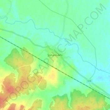
Name: Sonamukhi topographic map, elevation, terrain.
Location: Sonamukhi, Bankura, West Bengal, 722207, India (23.26346 87.37390 23.34346 87.45390)
Average elevation: 203 ft
Minimum elevation: 154 ft
Maximum elevation: 292 ft
Thank you for supporting this site ❤️
Make a donation
Make a donation
Gear up for your next adventure:
As an Amazon Associate, this site earns from qualifying purchases at no extra cost to you.