
Make a donation
Gear up for your next adventure:
As an Amazon Associate, this site earns from qualifying purchases at no extra cost to you.
Maruleng Ward 6 topographic map
Click on the map to display elevation.
Make a donation
Gear up for your next adventure:
As an Amazon Associate, this site earns from qualifying purchases at no extra cost to you.
About this map
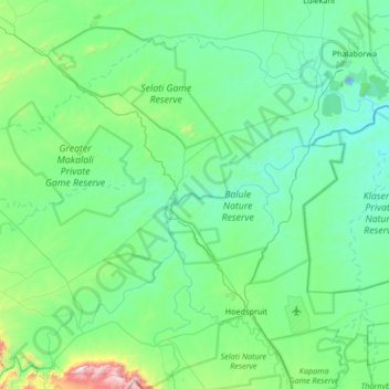
Name: Maruleng Ward 6 topographic map, elevation, terrain.
Average elevation: 1,627 ft
Minimum elevation: 942 ft
Maximum elevation: 5,928 ft
Make a donation
Gear up for your next adventure:
As an Amazon Associate, this site earns from qualifying purchases at no extra cost to you.
Other topographic maps
Click on a map to view its topography, its elevation and its terrain.
Hoedspruit
South Africa > Limpopo > Mopani District Municipality > Maruleng Local Municipality
Average elevation: 1,719 ft
Zandspruit
South Africa > Limpopo > Mopani District Municipality > Maruleng Local Municipality
Average elevation: 1,775 ft
The Oaks
South Africa > Limpopo > Mopani District Municipality > Maruleng Local Municipality
Average elevation: 1,585 ft
Zandspruit
South Africa > Limpopo > Mopani District Municipality > Maruleng Local Municipality > Hoedspruit
Average elevation: 1,677 ft
Make a donation
Gear up for your next adventure:
As an Amazon Associate, this site earns from qualifying purchases at no extra cost to you.
Hoedspruit
South Africa > Limpopo > Mopani District Municipality > Maruleng Local Municipality
Average elevation: 1,719 ft
Hoedspruit
South Africa > Limpopo > Mopani District Municipality > Maruleng Local Municipality
Average elevation: 1,719 ft
Ga-Selati
South Africa > Limpopo > Mopani District Municipality > Maruleng Local Municipality
Average elevation: 2,218 ft