
Make a donation
Gear up for your next adventure:
As an Amazon Associate, this site earns from qualifying purchases at no extra cost to you.
Groves topographic map
Click on the map to display elevation.
Make a donation
Gear up for your next adventure:
As an Amazon Associate, this site earns from qualifying purchases at no extra cost to you.
Groves
According to the United States Census Bureau, the city of Groves has a total area of 5.2 square miles (13.4 km2), of which 0.015 square miles (0.04 km2), or 0.28%, are water. Most of the city sits at an elevation of 5 to 15 feet (1.5 to 4.6 m) above sea level.
Make a donation
Gear up for your next adventure:
As an Amazon Associate, this site earns from qualifying purchases at no extra cost to you.
About this map
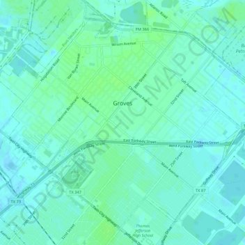
Name: Groves topographic map, elevation, terrain.
Location: Groves, Jefferson County, Texas, 77619, United States (29.92488 -93.94477 29.96423 -93.89173)
Average elevation: 13 ft
Minimum elevation: -7 ft
Maximum elevation: 30 ft
Jefferson County trails, hiking, mountain biking, running and outdoor activities
Make a donation
Gear up for your next adventure:
As an Amazon Associate, this site earns from qualifying purchases at no extra cost to you.
Other topographic maps
Click on a map to view its topography, its elevation and its terrain.
Make a donation
Gear up for your next adventure:
As an Amazon Associate, this site earns from qualifying purchases at no extra cost to you.
Griffing Park
United States > Texas > Jefferson County > Port Arthur > Griffing Park
Average elevation: 13 ft