
Make a donation
Gear up for your next adventure:
As an Amazon Associate, this site earns from qualifying purchases at no extra cost to you.
Pillichsdorf topographic map
Click on the map to display elevation.
Make a donation
Gear up for your next adventure:
As an Amazon Associate, this site earns from qualifying purchases at no extra cost to you.
About this map
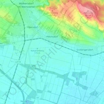
Name: Pillichsdorf topographic map, elevation, terrain.
Location: Pillichsdorf, Bezirk Mistelbach, Lower Austria, 2211, Austria (48.32528 16.51216 48.38588 16.56574)
Average elevation: 584 ft
Minimum elevation: 512 ft
Maximum elevation: 869 ft
Make a donation
Gear up for your next adventure:
As an Amazon Associate, this site earns from qualifying purchases at no extra cost to you.
Other topographic maps
Click on a map to view its topography, its elevation and its terrain.
Wolfpassing an der Hochleithen
Austria > Lower Austria > Bezirk Mistelbach > Gemeinde Hochleithen
Average elevation: 791 ft
Make a donation
Gear up for your next adventure:
As an Amazon Associate, this site earns from qualifying purchases at no extra cost to you.
Michelstetten
Austria > Lower Austria > Bezirk Mistelbach > Gemeinde Asparn an der Zaya
Average elevation: 1,050 ft
Wolkersdorf im Weinviertel
Austria > Lower Austria > Bezirk Mistelbach > Gemeinde Wolkersdorf im Weinviertel
Average elevation: 676 ft