Geolocate

Maybancal topographic map

Click on the map to display elevation.

About this map

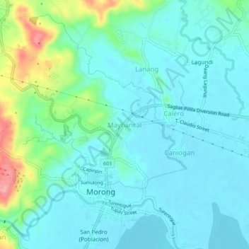
Name: Maybancal topographic map, elevation, terrain.

Location: Maybancal, Morong, Rizal, Calabarzon, 1960, Philippines (14.50588 121.22202 14.54588 121.26202)

Average elevation: 89 ft

Minimum elevation: -3 ft

Maximum elevation: 423 ft

Other topographic maps

Click on a map to view its topography, its elevation and its terrain.

Morong Plaza

Philippines > Rizal > Morong > Caniogan

Average elevation: 43 ft

Gear up for your next adventure:

🧭Hiking Compass - Precision compass for reliable navigation in the wilderness
🥤Water Filter Bottle - All‑in‑one filter bottle for safe hydration
💧Water Purification System - Clean water on the trail with reliable purifiers
🌲Outdoor Survival Books - Best books on survival skills
☀️Outdoor Sunscreen - High protection sunscreen for outdoor activities

As an Amazon Associate, this site earns from qualifying purchases at no extra cost to you.