Geolocate

Waverly topographic map

Click on the map to display elevation.

About this map

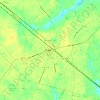
Name: Waverly topographic map, elevation, terrain.

Location: Waverly, Sussex County, Virginia, United States (37.01850 -77.12450 37.05302 -77.07273)

Average elevation: 108 ft

Minimum elevation: 62 ft

Maximum elevation: 131 ft

Sussex County trails, hiking, mountain biking, running and outdoor activities

Other topographic maps

Click on a map to view its topography, its elevation and its terrain.

Yale

United States > Virginia > Sussex County

Average elevation: 102 ft

Homeville

United States > Virginia > Sussex County

Average elevation: 98 ft

Gear up for your next adventure:

🛌Ultralight Sleeping Bags - Compact down bags for cold nights in the wilderness
🥩Freeze-Dried Meals - Nutritious and lightweight food for remote expeditions
🔥Camping Stove - Portable stove for camping and backcountry cooking
🪶Compact Camp Shovel - Folding shovel for campsite tasks
🌧️Backpack Rain Cover - Keep gear dry in wet weather

As an Amazon Associate, this site earns from qualifying purchases at no extra cost to you.