
Make a donation
Gear up for your next adventure:
As an Amazon Associate, this site earns from qualifying purchases at no extra cost to you.
Bismarck topographic map
Click on the map to display elevation.
Make a donation
Gear up for your next adventure:
As an Amazon Associate, this site earns from qualifying purchases at no extra cost to you.
About this map
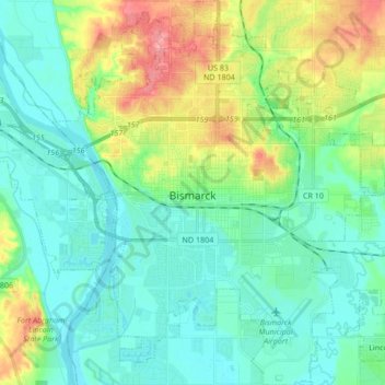
Name: Bismarck topographic map, elevation, terrain.
Location: Bismarck, Burleigh County, North Dakota, United States (46.75111 -100.84561 46.88149 -100.68853)
Average elevation: 1,729 ft
Minimum elevation: 1,614 ft
Maximum elevation: 1,982 ft
Burleigh County trails, hiking, mountain biking, running and outdoor activities
Make a donation
Gear up for your next adventure:
As an Amazon Associate, this site earns from qualifying purchases at no extra cost to you.
Other topographic maps
Click on a map to view its topography, its elevation and its terrain.
Bismarck Conservation and Outdoor Skills Area
United States > North Dakota > Burleigh County > Bismarck
Average elevation: 1,683 ft