
Make a donation
Gear up for your next adventure:
As an Amazon Associate, this site earns from qualifying purchases at no extra cost to you.
Bekenu topographic map
Click on the map to display elevation.
Make a donation
Gear up for your next adventure:
As an Amazon Associate, this site earns from qualifying purchases at no extra cost to you.
About this map
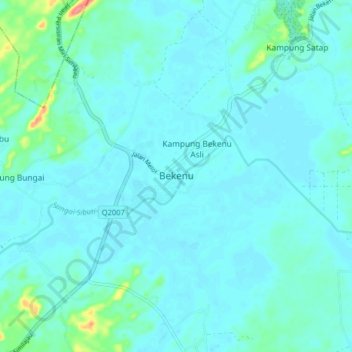
Name: Bekenu topographic map, elevation, terrain.
Location: Bekenu, Subis, Miri Division, Sarawak, 98150, Malaysia (4.01783 113.80608 4.09783 113.88608)
Average elevation: 30 ft
Minimum elevation: 0 ft
Maximum elevation: 249 ft
Make a donation
Gear up for your next adventure:
As an Amazon Associate, this site earns from qualifying purchases at no extra cost to you.
Other topographic maps
Click on a map to view its topography, its elevation and its terrain.
The Archaeological Heritage of Niah National Park’s Caves Complex
Malaysia > Sarawak > Subis > Batu Niah
Average elevation: 174 ft
The Archaeological Heritage of Niah National Park’s Caves Complex
Malaysia > Sarawak > Subis > Batu Niah
Average elevation: 174 ft
The Archaeological Heritage of Niah National Park’s Caves Complex
Malaysia > Sarawak > Subis > Batu Niah
Average elevation: 174 ft
Make a donation
Gear up for your next adventure:
As an Amazon Associate, this site earns from qualifying purchases at no extra cost to you.