
Make a donation
Gear up for your next adventure:
As an Amazon Associate, this site earns from qualifying purchases at no extra cost to you.
Rio Chapecó topographic map
Click on the map to display elevation.
Make a donation
Gear up for your next adventure:
As an Amazon Associate, this site earns from qualifying purchases at no extra cost to you.
About this map
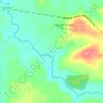
Name: Rio Chapecó topographic map, elevation, terrain.
Average elevation: 4,124 ft
Minimum elevation: 4,029 ft
Maximum elevation: 4,308 ft
Make a donation
Gear up for your next adventure:
As an Amazon Associate, this site earns from qualifying purchases at no extra cost to you.
Other topographic maps
Click on a map to view its topography, its elevation and its terrain.
Colônia Vista Alegre
Brasil > Santa Catarina > Água Doce > Colônia Vista Alegre
Average elevation: 4,101 ft
Make a donation
Gear up for your next adventure:
As an Amazon Associate, this site earns from qualifying purchases at no extra cost to you.
Fazenda Renascença
Brasil > Santa Catarina > Água Doce > Fazenda Renascença
Average elevation: 4,177 ft