Geolocate

Brockenhurst topographic map

Click on the map to display elevation.

About this map

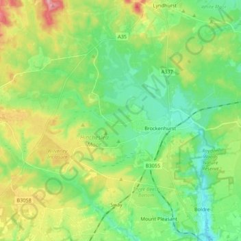
Name: Brockenhurst topographic map, elevation, terrain.

Location: Brockenhurst, New Forest, Hampshire, England, United Kingdom (50.78386 -1.68877 50.86131 -1.52268)

Average elevation: 112 ft

Minimum elevation: -3 ft

Maximum elevation: 367 ft

Other topographic maps

Click on a map to view its topography, its elevation and its terrain.

Brook

United Kingdom > England > Hampshire > New Forest > Bramshaw

Average elevation: 213 ft

Dibden

United Kingdom > England > Hampshire > New Forest

Average elevation: 56 ft

Winsor

United Kingdom > England > Hampshire > New Forest

Average elevation: 89 ft

Half Moon

United Kingdom > England > Hampshire > New Forest

Average elevation: 118 ft

Ower

United Kingdom > England > Hampshire > New Forest

Average elevation: 79 ft

Gear up for your next adventure:

🩹Survival Bandages - High‑quality bandages for emergencies
🔭Stargazing Telescopes - Perfect for camping in low-light pollution areas shown on maps
🛠️Outdoor Gear Repair Kit - Essential tools to fix gear on the trail
Solar GPS Watches - Advanced multisport watches with built-in topographic maps
🏫Relief Map Kits - Hands-on tools for teaching landforms and elevation

As an Amazon Associate, this site earns from qualifying purchases at no extra cost to you.