Geolocate

Fish Creek topographic map

Click on the map to display elevation.

About this map

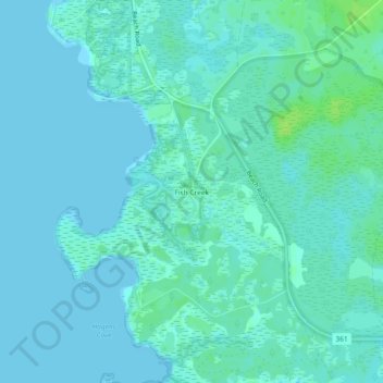
Name: Fish Creek topographic map, elevation, terrain.

Location: Fish Creek, Taylor County, Florida, United States (29.76633 -83.59209 29.80633 -83.55209)

Average elevation: 10 ft

Minimum elevation: -10 ft

Maximum elevation: 36 ft

Other topographic maps

Click on a map to view its topography, its elevation and its terrain.

Perry

United States > Florida > Taylor County

Average elevation: 52 ft

Perry

United States > Florida > Taylor County

Average elevation: 52 ft

channel

United States > Florida > Taylor County > Keaton Beach

Average elevation: 0 ft

Gear up for your next adventure:

🧥Waterproof Jacket for Hiking - Breathable and rugged rain jacket for outdoor excursions
🌡️Portable Weather Meter - Track weather conditions on the trail
🏥Hiking First Aid Kits - Comprehensive medical kits for remote trail injuries
🌲Outdoor Survival Books - Best books on survival skills
📱Solar Portable Charger - Solar power bank for charging devices off‑grid

As an Amazon Associate, this site earns from qualifying purchases at no extra cost to you.