
Chetouane topographic map
Interactive map
Click on the map to display elevation.
About this map
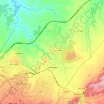
Name: Chetouane topographic map, elevation, terrain.
Location: Chetouane, Daïra Chetouane, Tlemcen, 13048, Algérie (34.89362 -1.34558 34.97451 -1.23634)
Average elevation: 1,791 ft
Minimum elevation: 896 ft
Maximum elevation: 2,969 ft
Other topographic maps
Click on a map to view its topography, its elevation and its terrain.
Ouzidane
Algérie > Tlemcen > Daïra Chetouane > Chetouane
Ouzidane, Chetouane, Daïra Chetouane, Tlemcen, 13048, Algérie
Average elevation: 1,778 ft
Aïn Fezza
Algérie > Tlemcen > Daïra Chetouane
Aïn Fezza, Daïra Chetouane, Tlemcen, Algérie
Average elevation: 2,897 ft
Safsaf
Algérie > Tlemcen > Daïra Chetouane > Chetouane
Safsaf, Chetouane, Daïra Chetouane, Tlemcen, 13048, Algérie
Average elevation: 2,146 ft