
Matt topographic map
Click on the map to display elevation.
About this map
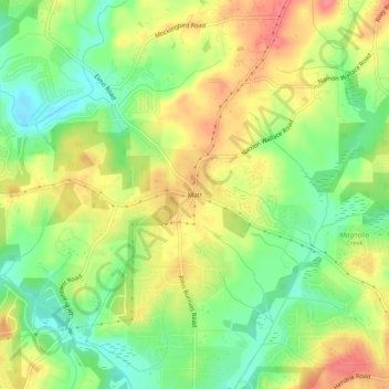
Name: Matt topographic map, elevation, terrain.
Location: Matt, Forsyth County, Georgia, 30028, United States (34.27871 -84.17297 34.31871 -84.13297)
Average elevation: 1,158 ft
Minimum elevation: 1,047 ft
Maximum elevation: 1,273 ft
Other topographic maps
Click on a map to view its topography, its elevation and its terrain.
Lake Lanier
United States > Georgia > Forsyth County > Cumming
According to the Army Corps of Engineers, the Dam has a current installed capacity of 126 megawatts and a hydraulic head of 136 feet. Other pertinent information on the reservoir, power plant, etc. can be found on the Mobile District Corps of Engineers web site.[12][13] Also, historic operational information…
Average elevation: 1,152 ft