
Make a donation
Gear up for your next adventure:
As an Amazon Associate, this site earns from qualifying purchases at no extra cost to you.
McCullom Lake topographic map
Click on the map to display elevation.
Make a donation
Gear up for your next adventure:
As an Amazon Associate, this site earns from qualifying purchases at no extra cost to you.
About this map
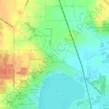
Name: McCullom Lake topographic map, elevation, terrain.
Location: McCullom Lake, McHenry County, Illinois, United States (42.36399 -88.30609 42.37645 -88.28437)
Average elevation: 801 ft
Minimum elevation: 741 ft
Maximum elevation: 892 ft
McHenry County trails, hiking, mountain biking, running and outdoor activities
Make a donation
Gear up for your next adventure:
As an Amazon Associate, this site earns from qualifying purchases at no extra cost to you.
Other topographic maps
Click on a map to view its topography, its elevation and its terrain.
Elizabeth Lake Nature Preserve
United States > Illinois > McHenry County > Twin Lakes
Average elevation: 820 ft
Make a donation
Gear up for your next adventure:
As an Amazon Associate, this site earns from qualifying purchases at no extra cost to you.