
Make a donation
Gear up for your next adventure:
As an Amazon Associate, this site earns from qualifying purchases at no extra cost to you.
Wulvergem topographic map
Click on the map to display elevation.
Make a donation
Gear up for your next adventure:
As an Amazon Associate, this site earns from qualifying purchases at no extra cost to you.
Wulvergem
Wulvergem ligt in Zandlemig Vlaanderen ten oosten van het West-Vlaams Heuvelland en de heuvelrug die de stroomgebieden van IJzer en Leie scheidt. op een hoogte van ongeveer 30 meter, aan de bovenloop van de Douvebeek. Het hoogste punt ligt op 78 meter. Wulvergem ligt nabij de landschappelijke Ankerplaats Ieperse vestingen en omgeving, bossen ten zuiden en heuvelrug Wijtschate-Mesen. Ten zuidoosten van Wulvergem vindt men het Ploegsteertbos.
Make a donation
Gear up for your next adventure:
As an Amazon Associate, this site earns from qualifying purchases at no extra cost to you.
About this map
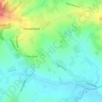
Name: Wulvergem topographic map, elevation, terrain.
Location: Wulvergem, Heuvelland, Ieper, West-Vlaanderen, 8952, België (50.75752 2.82409 50.77778 2.86074)
Average elevation: 148 ft
Minimum elevation: 75 ft
Maximum elevation: 253 ft
Make a donation
Gear up for your next adventure:
As an Amazon Associate, this site earns from qualifying purchases at no extra cost to you.
Other topographic maps
Click on a map to view its topography, its elevation and its terrain.
Make a donation
Gear up for your next adventure:
As an Amazon Associate, this site earns from qualifying purchases at no extra cost to you.