
Thank you for supporting this site ❤️
Make a donation
Make a donation
Gear up for your next adventure:
As an Amazon Associate, this site earns from qualifying purchases at no extra cost to you.
Zandvoorde topographic map
Click on the map to display elevation.
Thank you for supporting this site ❤️
Make a donation
Make a donation
Gear up for your next adventure:
As an Amazon Associate, this site earns from qualifying purchases at no extra cost to you.
About this map
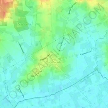
Name: Zandvoorde topographic map, elevation, terrain.
Location: Zandvoorde, Zonnebeke, Ieper, West Flanders, Flanders, Belgium (50.80011 2.95288 50.83018 3.00017)
Average elevation: 95 ft
Minimum elevation: 56 ft
Maximum elevation: 190 ft
Thank you for supporting this site ❤️
Make a donation
Make a donation
Gear up for your next adventure:
As an Amazon Associate, this site earns from qualifying purchases at no extra cost to you.
Other topographic maps
Click on a map to view its topography, its elevation and its terrain.
Polderhoek
Belgium > West Flanders > Ieper > Zonnebeke > Geluveld > Poezelhoek
Average elevation: 148 ft