Geolocate

Buchau topographic map

Click on the map to display elevation.

About this map

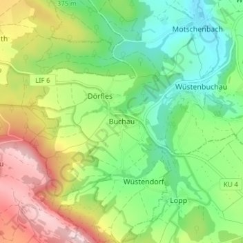
Name: Buchau topographic map, elevation, terrain.

Location: Buchau, Mainleus, Landkreis Kulmbach, Bavaria, Germany (50.05598 11.30063 50.09598 11.34063)

Average elevation: 1,296 ft

Minimum elevation: 971 ft

Maximum elevation: 1,811 ft

Other topographic maps

Click on a map to view its topography, its elevation and its terrain.

Stadtsteinach

Germany > Bavaria > Landkreis Kulmbach

Average elevation: 1,532 ft

Kupferberg

Germany > Bavaria > Landkreis Kulmbach

Average elevation: 1,608 ft

Kulmbach

Germany > Bavaria > Landkreis Kulmbach

Average elevation: 1,296 ft

Grafengehaig

Germany > Bavaria > Landkreis Kulmbach

Average elevation: 1,873 ft

Wonsees

Germany > Bavaria > Landkreis Kulmbach

Average elevation: 1,542 ft

Gear up for your next adventure:

🧢Outdoor Hiking Hat - Sun protection hat for outdoor explorers
🧯Portable Fire Pit - Compact fire pit for camping spots
🪑Ultralight Camp Chairs - Portable seating for resting after a long day of mapping
🪶Compact Camp Shovel - Folding shovel for campsite tasks
🧺Microfiber Travel Towels - Compact and fast-drying towels for trail use

As an Amazon Associate, this site earns from qualifying purchases at no extra cost to you.