
Thank you for supporting this site ❤️
Make a donation
Make a donation
Gear up for your next adventure:
As an Amazon Associate, this site earns from qualifying purchases at no extra cost to you.
Tultitlán topographic map
Click on the map to display elevation.
Thank you for supporting this site ❤️
Make a donation
Make a donation
Gear up for your next adventure:
As an Amazon Associate, this site earns from qualifying purchases at no extra cost to you.
About this map
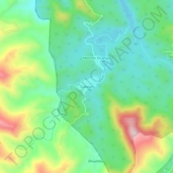
Name: Tultitlán topographic map, elevation, terrain.
Location: Tultitlán, San Felipe Orizatlán, Hidalgo, 43167, México (21.10667 -98.67111 21.14667 -98.63111)
Average elevation: 1,129 ft
Minimum elevation: 732 ft
Maximum elevation: 1,952 ft
Thank you for supporting this site ❤️
Make a donation
Make a donation
Gear up for your next adventure:
As an Amazon Associate, this site earns from qualifying purchases at no extra cost to you.