
Make a donation
Gear up for your next adventure:
As an Amazon Associate, this site earns from qualifying purchases at no extra cost to you.
Vepanapalli topographic map
Click on the map to display elevation.
Make a donation
Gear up for your next adventure:
As an Amazon Associate, this site earns from qualifying purchases at no extra cost to you.
About this map
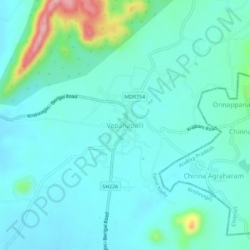
Name: Vepanapalli topographic map, elevation, terrain.
Location: Vepanapalli, Krishnagiri, Tamil Nadu, 635114, India (12.68229 78.17381 12.72229 78.21381)
Average elevation: 1,949 ft
Minimum elevation: 1,847 ft
Maximum elevation: 2,428 ft
Make a donation
Gear up for your next adventure:
As an Amazon Associate, this site earns from qualifying purchases at no extra cost to you.
Other topographic maps
Click on a map to view its topography, its elevation and its terrain.
Kaveripattinam
India > Tamil Nadu > Krishnagiri
Kaveripattinam is located at 12°25′N 78°14′E / 12.42°N 78.23°E / 12.42; 78.23 on the NH 44, a major north–south National Highway, one of the longest and busiest road in the country. It has an average elevation of 533 metres (1,749 ft). This town has a cool climate. It lies on the bank of the…
Average elevation: 1,516 ft