Geolocate

Combapata topographic map

Interactive map

Click on the map to display elevation.

About this map

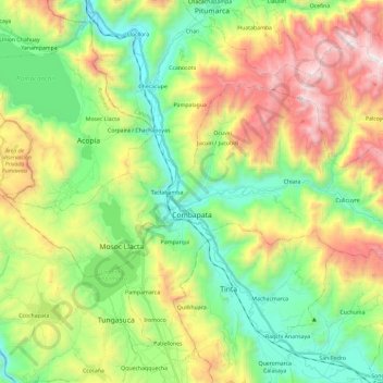
Name: Combapata topographic map, elevation, terrain.

Location: Combapata, Canchis, Cusco, Peru (-14.15186 -71.44429 -14.02361 -71.20997)

Average elevation: 12,881 ft

Minimum elevation: 11,047 ft

Maximum elevation: 16,020 ft

Other topographic maps

Click on a map to view its topography, its elevation and its terrain.

San Miguel

Peru > Cusco > Machupicchu > Intihuatana

San Miguel, Intihuatana, Machupicchu, Urubamba, Cusco, 08680, Peru

Average elevation: 7,421 ft

Quelccaya

Peru > Cusco > Checacupe

Quelccaya, Checacupe, Canchis, Cusco, Peru

Average elevation: 16,952 ft

Urcos

Peru > Cusco > Urcos

Urcos, Quispicanchi, Cusco, Peru

Average elevation: 12,244 ft

Checacupe

Peru > Cusco > Checacupe

Checacupe, Canchis, Cusco, Peru

Average elevation: 11,729 ft

Canchis

Peru > Cusco > San Pablo

Canchis, San Pablo, Canchis, Cusco, Peru

Average elevation: 14,879 ft

Nevado Huila Aje

Peru > Cusco > Pitumarca

Nevado Huila Aje, Pitumarca, Canchis, Cusco, Peru

Average elevation: 17,694 ft

Quispicanchi

Peru > Cusco

Quispicanchi, Cusco, Peru

Average elevation: 9,580 ft