
Make a donation
Gear up for your next adventure:
As an Amazon Associate, this site earns from qualifying purchases at no extra cost to you.
Kotagiri topographic map
Click on the map to display elevation.
Make a donation
Gear up for your next adventure:
As an Amazon Associate, this site earns from qualifying purchases at no extra cost to you.
Kotagiri
Kotagiri is a Hill town and a taluk in The Nilgiris District in the Indian state of Tamil Nadu. The name 'Kota-giri' itself means 'mountain of the Kotas'. The town has developed around numerous knolls and valleys. It is one of the largest hill station in the Nilgiri Mountains. Located at an average elevation of 1,950 m (6,400 ft), Kotagiri is quietly tucked away in the Nilgiris and used to be one of the summer resort of Madras Presidency. The town was discovered in the year 1819 by John Sullivan when he came to a village called Dhimbatty to the North of Kotagiri. Situated at an elevation of about 6,400 feet, Kotagiri enjoys the third coldest climate next to Ooty and Kodaikanal in South India.
Make a donation
Gear up for your next adventure:
As an Amazon Associate, this site earns from qualifying purchases at no extra cost to you.
About this map
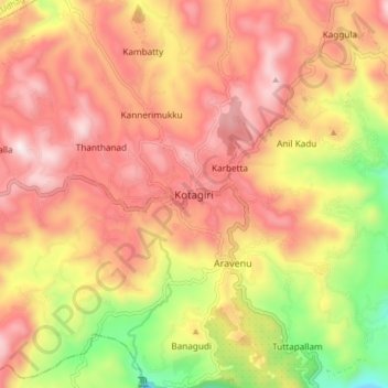
Name: Kotagiri topographic map, elevation, terrain.
Location: Kotagiri, Nilgiris, Tamil Nadu, 643217, India (11.38304 76.82582 11.46304 76.90582)
Average elevation: 5,843 ft
Minimum elevation: 4,232 ft
Maximum elevation: 6,972 ft
Make a donation
Gear up for your next adventure:
As an Amazon Associate, this site earns from qualifying purchases at no extra cost to you.
Other topographic maps
Click on a map to view its topography, its elevation and its terrain.