
Thank you for supporting this site ❤️
Make a donation
Make a donation
Gear up for your next adventure:
As an Amazon Associate, this site earns from qualifying purchases at no extra cost to you.
Sonewadi topographic map
Click on the map to display elevation.
Thank you for supporting this site ❤️
Make a donation
Make a donation
Gear up for your next adventure:
As an Amazon Associate, this site earns from qualifying purchases at no extra cost to you.
About this map
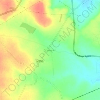
Name: Sonewadi topographic map, elevation, terrain.
Location: Sonewadi, Ahmednagar, Maharashtra, 414005, India (19.00586 74.66070 19.04586 74.70070)
Average elevation: 2,257 ft
Minimum elevation: 2,169 ft
Maximum elevation: 2,349 ft
Thank you for supporting this site ❤️
Make a donation
Make a donation
Gear up for your next adventure:
As an Amazon Associate, this site earns from qualifying purchases at no extra cost to you.