
Thank you for supporting this site ❤️
Make a donation
Make a donation
Gear up for your next adventure:
As an Amazon Associate, this site earns from qualifying purchases at no extra cost to you.
Voort topographic map
Click on the map to display elevation.
Thank you for supporting this site ❤️
Make a donation
Make a donation
Gear up for your next adventure:
As an Amazon Associate, this site earns from qualifying purchases at no extra cost to you.
About this map
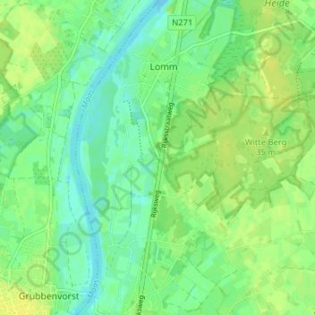
Name: Voort topographic map, elevation, terrain.
Location: Voort, Velden, Venlo, Limburg, Nederland, 5941 NM, Nederland (51.41710 6.15068 51.45710 6.19068)
Average elevation: 69 ft
Minimum elevation: 39 ft
Maximum elevation: 92 ft
Thank you for supporting this site ❤️
Make a donation
Make a donation
Gear up for your next adventure:
As an Amazon Associate, this site earns from qualifying purchases at no extra cost to you.