
Make a donation
Gear up for your next adventure:
As an Amazon Associate, this site earns from qualifying purchases at no extra cost to you.
Caleta Tumbes topographic map
Click on the map to display elevation.
Make a donation
Gear up for your next adventure:
As an Amazon Associate, this site earns from qualifying purchases at no extra cost to you.
About this map
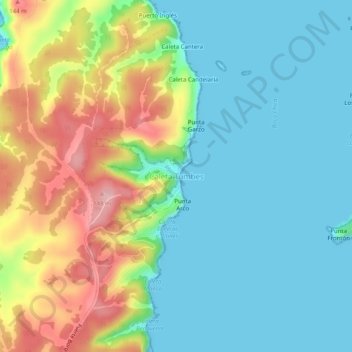
Name: Caleta Tumbes topographic map, elevation, terrain.
Average elevation: 167 ft
Minimum elevation: -7 ft
Maximum elevation: 525 ft
Make a donation
Gear up for your next adventure:
As an Amazon Associate, this site earns from qualifying purchases at no extra cost to you.
Other topographic maps
Click on a map to view its topography, its elevation and its terrain.
Bahía de Concepción
Chile > Región del Biobío > Provincia de Concepción > Talcahuano
Average elevation: 125 ft
Isla Quiriquina
Chile > Región del Biobío > Provincia de Concepción > Talcahuano
Average elevation: 33 ft
Parque Tumbes
Chile > Región del Biobío > Provincia de Concepción > Talcahuano
Average elevation: 167 ft
Isla Quiriquina
Chile > Región del Biobío > Provincia de Concepción > Talcahuano
Average elevation: 33 ft
Make a donation
Gear up for your next adventure:
As an Amazon Associate, this site earns from qualifying purchases at no extra cost to you.