
Lacombe topographic map
Click on the map to display elevation.
About this map
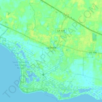
Name: Lacombe topographic map, elevation, terrain.
Location: Lacombe, St. Tammany Parish, Louisiana, 70445, United States (30.24687 -89.98087 30.37158 -89.87620)
Average elevation: 13 ft
Minimum elevation: -10 ft
Maximum elevation: 33 ft
St. Tammany Parish trails, hiking, mountain biking, running and outdoor activities
Other topographic maps
Click on a map to view its topography, its elevation and its terrain.
Covington
United States > Louisiana > St. Tammany Parish > Covington > Covington
Average elevation: 30 ft